
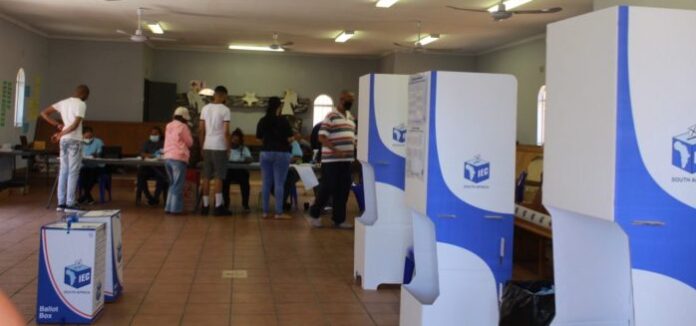
A nation that remains structurally disconnected from itself is doomed to mistake political theatre for substantive transformation. In South Africa’s socio-political calendar, dates such as November 4 are frequently heralded as monumental markers of democratic accountability and civic renewal. Yet, when interrogated through the cold, uncompromising lens of empirical data, these dates often collapse into performative rituals — empty ceremonies divorced from the stubborn material realities of ordinary citizens.
To understand why this disconnect persists, we must look past the superficial gloss of election campaigns and examine the deep, unyielding fractures exposed by rigorous spatial and demographic diagnostics.
Situated in the eastern part of the North West province, Moruleng serves as a compelling microcosm of South Africa’s developmental enigma. It is a region rich in heritage and mineral wealth, yet its communities grapple with persistent service delivery deficits and infrastructural disconnects. To understand why an electoral milestone such as November 4 matters yet simultaneously feels detached from the lived experience, we must look beyond political rhetoric and interrogate the empirical architecture of space and time.
The diagnostic imperative: instruments and metadata
To evaluate systemic functionality or dysfunction, opinion cannot replace evidence. As deployed across our analytical frameworks, valid metadata is the bedrock of credible socio-economic diagnosis.
Drawing from the 2 752 evidence-based analytical instruments of The Lehohla Ledger, we apply rigorous diagnostics to isolate structural bottlenecks. Specifically, instruments such as spatial autocorrelation indices (including Moran’s I) and longitudinal demographic tracking allow us to examine how wealth extraction and local impoverishment coexist within the same municipal boundaries. Without these instruments and their accompanying metadata, policy debates remain adrift in conjecture.
Tracing the census mesh: From 1996 to 2022
Electoral promises are transient, but the census mesh tells an enduring, unvarnished story. If we zoom into Moruleng by examining specific place names within local wards, we uncover the true pulse of transformation across a quarter-century.
By tracking contiguous Enumeration Areas (EAs) across the 1996, 2001, 2011, and 2022 Censuses of South Africa, a granular spatial mesh emerges:
The 1996 Baseline: Captured the post-transition administrative baseline, establishing initial infrastructural distributions under severe historical backlogs.
The 2001 and 2011 Shifts: Highlighted uneven urbanization, localized capital investments, and the sluggish pace of basic service rollout despite rising mineral extraction revenues in the surrounding platinum belt.
The 2022 Horizon: Revealed the compounding pressures of demographic growth, youth unemployment, and spatial fragmentation, underscoring why structural interventions are urgently required.
This spatial mesh demonstrates that changes at the EA level do not happen overnight; they require sustained, systematic execution rather than episodic electoral enthusiasm.
Why November 4 matters – and why it does not
Why, then, does November 4 matter, yet fail to move the needle?
It matters because elections provide the constitutional mechanism for citizens to demand accountability, recalibrate local governance, and reset the social contract. It does not matter if the political machinery treats November 4 as an isolated ritual rather than an ongoing commitment to spatial justice and economic inclusion. When governance is disconnected from the census mesh—when planners ignore the empirical realities of small-area statistics—elections become empty exercises in procedural democracy.
The case of Moruleng teaches us that true development requires bridging the gap between electoral calendars and everyday survival. Only when state capability matches community resilience will the promise of dates like November 4 finally align with the lived reality on the ground.
The diagnostic lens: instruments, metadata, and truth
Opinion and political rhetoric cannot substitute for systematic measurement. To diagnose why governance fails at the local level, we must deploy valid metadata and rigorous analytical instruments.
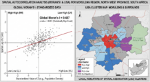
Drawing directly from the 2 752 evidence-based analytical instruments of The Lehohla Ledger, we apply advanced spatial autocorrelation metrics—such as Moran’s I and Local Indicators of Spatial Association (LISA)—to evaluate socio-economic disparities. These instruments reveal a sobering truth: inequality in South Africa is not random; it is tightly clustered, statistically stubborn, and systematically reinforced by planning failures. Without these empirical guardrails, public policy remains a guessing game, and dates on the calendar remain hollow symbols.
Tracing the census mesh: 1996 to 2022
Elections come and go, but the census mesh tells an enduring, unvarnished story of a society struggling to cohere. By examining specific placenames within municipal wards and tracking contiguous Enumeration Areas (EAs) across the 1996, 2001, 2011, and 2022 Censuses of South Africa, we map the true trajectory of our developmental journey:
The 1996 Baseline: Documented the staggering infrastructural backlogs inherited at the dawn of democracy.
The 2001 and 2011 Vintages: Highlighted the glacial pace of spatial integration and the emergence of informal settlements as desperate safety valves for an excluded labor force.
The 2022 Horizon: Exposed the compounding pressures of high youth unemployment, service delivery collapse, and deepening spatial fragmentation.
This granular census mesh proves that social cohesion cannot be legislated by decree or celebrated on a specific calendar date. It requires a generational commitment to repairing the infrastructural and economic fabric at the smallest possible geographic scale.
The illusion of cohesion: A nation divided by design
South Africa’s fundamental crisis is not merely economic; it is deeply spatial. Decades after the formal dismantling of apartheid, the physical architecture of our towns, townships, and rural settlements remains largely unchanged.
When political leaders invoke dates like November 4 as turning points for national unity, they routinely ignore the spatial apartheid encoded into our geography. Wealth remains hyper-concentrated in insulated urban enclaves, while poverty is spatially relegated to peripheral zones and historical homelands. In these neglected spaces, basic service delivery is erratic, infrastructure is crumbling, and economic opportunity is practically non-existent.
Governance that treats an election date as a finish line rather than a starting point for structural repair guarantees that the nation remains permanently estranged from itself.
Whither November 4? From ritual to developmental mandate
Whither November 4, then? If it remains merely a performative ritual where citizens cast ballots only to be forgotten until the next electoral cycle, democracy hollows out from within.
For November 4 to matter as a true developmental mandate, the state must align its planning machinery with the empirical warnings of the census mesh. Local government must be re-engineered around small-area estimation, spatial justice, and accountability that persists long after the polling stations close.
Until state capability matches the resilience of our communities, South Africa will continue to look into the mirror of its own statistics and see a nation tragically disconnected from itself.
- Moruleng in South Africa's North West province exemplifies the country's developmental challenges, with rich mineral wealth but persistent service delivery deficits and infrastructural disconnects.
- Analysis of South African census data from 1996 to 2022 shows slow infrastructure development, uneven urbanization, and growing youth unemployment in Moruleng despite rising mineral revenues.
- Electoral dates like November 4 hold constitutional importance for accountability but often become empty rituals when governance ignores empirical data on spatial and socio-economic disparities.
- The Lehohla Ledger's 2,752 analytical instruments, including spatial autocorrelation indices like Moran's I, reveal that inequality in South Africa is clustered, statistically stubborn, and sustained by planning failures.
- True development requires continuous commitment to spatial justice and economic inclusion beyond election days, aligning state capacity with community resilience through data-driven local governance.