
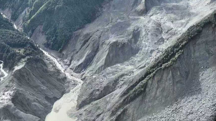
A powerful mudslide struck Gyirong County in southwest China’s Xizang Autonomous Region on Wednesday. Experts say a combination of extreme terrain, a massive volume of material and the sudden nature of the triggering event made the disaster particularly destructive.
Gyirong County, administered by the city of Xigaze, lies on the southern slopes of the Himalayas, facing Nepal across the Donglin Zangbo River.
Xu Qiang, president of Chengdu University of Technology and chief scientist at the State Key Laboratory of Geohazard Prevention and Geoenvironment Protection, said several factors contributed to the mudslide’s sudden onset and destructive power.
Enormous elevation difference, steep terrain
The first was the enormous elevation difference and steep terrain. The mountain behind the affected area rises to 6,781 metres, while the source area of the ice and rock avalanche is estimated to be at an altitude of around 5,000 metres. Gyirong Port, by comparison, sits at about 1,830 metres above sea level. The elevation difference of several thousand meters and the steep slopes allowed the mass of ice, rocks and sediment to rapidly gain speed as it moved downhill. Once transformed into a mudslide, it traveled with tremendous force.
The second factor was the huge volume of material involved. While an exact figure has yet to be determined, Xu said the volume of material could reach tens of millions of cubic metres, providing an enormous source for the mudslide.
A third factor was the area’s high exposure to the disaster. Many homes are located along the path of the mudslide, and the affected area is near the confluence of three rivers, making it particularly vulnerable to the destructive force of the rapidly moving material.
Abrupt nature of ice and rock avalanche
The fourth factor was the sudden nature of the ice and rock avalanche that triggered the disaster. Unlike mudslides triggered by heavy rainfall and gradually supplied with water and loose material, an ice and rock avalanche can occur abruptly. Once the collapsing mass enters a valley or river system, ice, rock and sediment can be rapidly transported downstream and develop into a powerful mudslide.
Together, these factors made the disaster exceptionally destructive, Xu said. A preliminary estimate, based on an average affected width of 200 metres, puts the affected area at around 15 to 20 square kilometres.
Risks from secondary disasters
Experts analysing imagery of the affected area said the region’s topographic and hydrological conditions are highly complex.
The disaster occurred near the junction of a main valley and a tributary, where the elevation difference exceeds 3,000 metres. Glaciers and glacial lakes are also located in the upper reaches.
These conditions have created significant challenges for rescue efforts.
One major uncertainty is the stability of the damaged mountain slope at the source area, which could pose a risk of secondary disasters. Water conditions in the upper reaches of both the main valley and tributaries also remain unclear.
Rainfall is another key concern. The area consists of high mountains, narrow valleys and concentrated water flows, meaning further rainfall could affect the stability of the disaster zone.
The narrow terrain also makes access difficult. Roads leading into and out of the affected area face potential threats from mountain collapses, landslides and falling rocks.
READ: Rescuers rush to mudslide-hit border port in southwest China’s Xizang
Hu Jiaojiao, a glaciology researcher and chair of the Tianjin Extreme Climate Change Response Promotion Center, said experts are continuing to monitor weather conditions and assess the risks of further scouring and geological instability.
The region also contains several sub-basins with major elevation differences, she said. It remains unclear whether additional ice and rock avalanches or mudslides could occur. Where rivers and tributaries are present, they can rapidly transport ice, rock and sediment downstream along valleys.
For rescue workers, the first challenge is the instability of the post-disaster natural environment. The second is operating at high altitude and under harsh conditions.
With limited personnel and resources, organising effective search, rescue and evacuation operations in such an extreme environment remains a major challenge.
- A mudslide struck Gyirong County in China's Xizang Autonomous Region, triggered by an ice and rock avalanche in the Himalayas with an elevation difference of several thousand meters.
- The volume of material involved in the mudslide could reach tens of millions of cubic metres, accelerating down steep terrain and impacting an estimated area of 15 to 20 square kilometres.
- The disaster area is highly exposed, with many homes along the mudslide path and complex topographic and hydrological conditions near the confluence of three rivers.
- Rescue efforts face significant challenges including unstable mountain slopes at the source, potential secondary disasters, unclear water conditions, and threats from further rainfall and landslides.
- Rescue operations are complicated by the high altitude, harsh environment, limited resources, and difficult access due to narrow valleys and roads prone to collapse.