
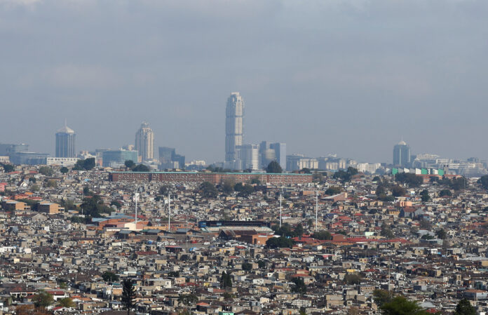
As South Africa edges toward the local government elections this November, standard political commentary remains trapped in the superficial theatre of manifesto launches, party floor-crossing, and national polling averages. Yet, beneath these volatile electoral swings lies a deeper, unyielding reality: the physical spatial architecture of our cities.
Through the developmental language of Lenaka la Mohlomi and the diagnostic architecture of the Lehohla Ledger, we can track how decades of unaddressed structural shifts have hardened into a permanent geography of civic fracture. The Ledger stands as the foundational body of work, providing a rigorous lexicon to decode the spatial realities of our time.
The 75-metre divide: Alexandra versus Sandton
Consider the stark empirical baseline established by tracing changes across four national censuses (1996, 2001, 2011, and 2022). Separated by a mere 75-metre ribbon of tar and steel – the M1 highway dividing Alexandra and Sandton – lie two completely different socio-economic universes.
Guided by the philosophy of Lenaka la Mohlomi, which demands that development be read through the indigenous and spatial pulse of the land, out of the 2752 instruments of the Lehohla Ledger we deploy Instrument number 525 (The Contiguity Coefficient). This instrument measures spatial autocorrelation and LISA clusters, revealing how spatial segregation evolved into a structural crisis.
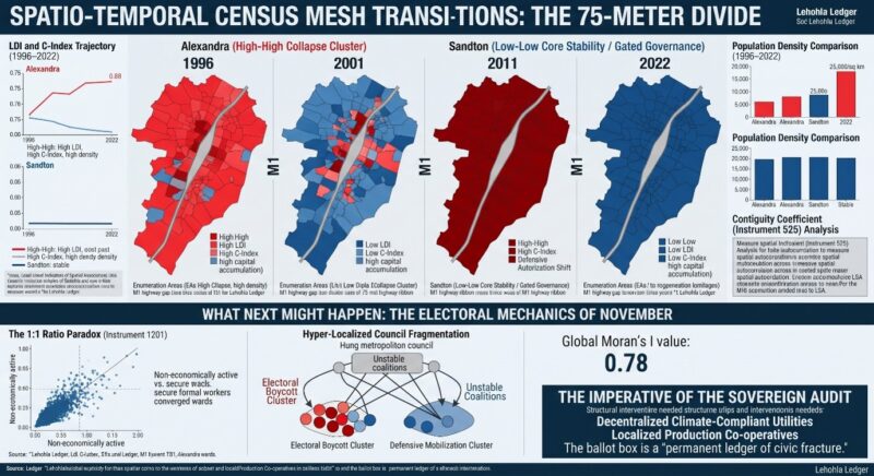
In the Alexandra mesh, rapid hyper-densification has seen population counts surge past 25,000 people per square kilometer in pockets like Stjwetla. Here, the Labour Disappearance Index (LDI) has pushed past 0.75, driven by the structural collapse of manufacturing employment and an explosion of informal, precarious survival strategies. Concurrently, the Democracy Collapse Index (C-Index) has escalated toward 0.88, manifesting as acute institutional alienation, recurrent service delivery protests, and chronic infrastructure failures such as persistent sewage spillages and refuse accumulation.
Directly across the M1 highway, the Sandton mesh maintains a Low-Low cluster trajectory anchored by private municipal management, securitized enclaves, and high formal capital accumulation. While democratic metrics here do not reflect traditional civic engagement decline, they instead exhibit an Authoritarian Shift – characterised by the privatisation of governance rather than absolute institutional abandonment. This spatial divergence invalidates aggregate municipal averages, rendering city-wide Gini coefficients functionally obsolete for localised policy design.
The 1:1 ratio paradox and fiscal inversion
To quantify the tipping point of non-economically active populations, the Lehohla Ledger deploys Instrument number 1201 (The 1:1 Ratio Paradox). In functional economic zones, the ratio of formally employed citizens to dependents heavily favors productivity – typically hovering around three tax contributors to every one dependent. However, longitudinal tracking within the inner-city core of Johannesburg (Hillbrow, Joubert Park, and Doornfontein) reveals a terminal inversion.
By the 2022 Census cycle, the ratio in the inner-city mesh inverted past 1:1, shifting rapidly toward one formally employed worker supporting four to five dependents or survivalists in the informal and underground economies. When LDI metrics exceed 0.80, formal wages cease to serve as the primary mechanism of social reproduction.
Households survive via fragmented remittances and survivalist micro-enterprises. Because municipal revenue collection relies entirely on a functional formal-to-dependent ratio, this 1:1 inversion triggers structural municipal insolvency, causing bulk infrastructure to collapse under the sheer density of an unmapped population.
Metropolitan autocorrelation and secondary hotspots
Expanding LISA mapping across the broader Johannesburg municipal landscape demonstrates that the Alexandra-Sandton divide is not an anomaly; it is the primary template of a wider metropolitan fracture. Calculating Local Moran’s I exposes a powerful spatial clustering of socio-economic distress:
- The Greater Soweto Core (Wards 15 to 55): Operating as a massive structural dormitory, densification per stand has overloaded aging bulk infrastructure, pushing the C-Index past 0.72 as youth unemployment collides with unfulfilled infrastructural promises.
- The Inner-City Core: Characterised by intense vertical densification and hijacked buildings, political representation here has fragmented into micro-warlordism and informal civic associations, turning the zone into an epicenter for electoral abstention.
- The Southern Periphery (Orange Farm and Ennerdale): Formed on the absolute margins of the municipal boundary, these areas exhibit classic High-High spatial autocorrelation for poverty, leaving residents to mobilise exclusively through disruptive service-delivery actions.
When synthesised with Global Moran’s I I (0.78, p < 0.001), the structural forecast for November is stark. The electoral map will display an unbridgeable chasm between protected commercial nodes where turnout remains defensively stable, and sprawling peripheral collapse clusters where 12 million disenfranchised citizens will register their protest through absence.
Furthermore, because spatial autocorrelation locks deprivation into contiguous blocks, independent civic movements will sweep ward-level contests, guaranteeing that post-election metropolitan governance will dissolve into hyper-fragmented coalition paralysis.
Strategic imperatives for structural renewal and instrument utility
Treating these fractures merely as campaign communication issues misses the reality of the census mesh. As framed within the developmental language of Lenaka laMohlomi, stabilising local government demands a fundamental restructuring of economic geography through the Sovereign Audit, operationalised via the specific utility of the Lehohla Ledger’s instruments:
- Decentralised Economic Engines:
Instrument 1420 (Small-Area Economic Mesh Mapping): Reconnects marginalised labor pools and informal survivalist micro-enterprises directly to regional value chains by diagnosing localised production bottlenecks at the enumeration area scale.
Instrument 812 (The Spatial Labor Reintegration Protocol): Evaluates local employment deficits to guide the placement of localized production hubs and cooperative incubators in high-LDI zones.
- Infrastructure Retrofitting:
Instrument 1901 (The Climate-Compliant Enthalpy Index / Decentralised Utilities): Bypasses failing municipal grid infrastructure by deploying localised, sustainable technologies to restore independent resource production.
Instrument 404 (Infrastructure Stress-Capacity Index): Quantifies stand density versus bulk pipe capacity to prioritise immediate asset retrofitting in hyper-dense dormitory meshes.
3. Data-Driven Accountability and Governance:
Instrument 525 (The Contiguity Coefficient): Maps spatial autocorrelation and LISA clusters to ensure municipal budgets follow actual human need rather than legacy zoning privileges.
Instrument 1201 (The 1:1 Ratio Paradox): Tracks the structural inversion of formally employed workers to dependents, providing the precise mathematical threshold required to restructure municipal revenue models and prevent fiscal insolvency.
- The Alexandra Mesh (High-High Collapse Cluster):
1996–2001: High initial population densities with a mixed base of formal and informal dwellings; economic linkages to surrounding industrial nodes were still intact, maintaining a functional – though strained – electoral participation rate.
2011–2022: Rapid hyper-densification (surpassing 25,000 people per square kilometre in spaces like Stjwetla). The Labour Disappearance Index (LDI) surged past 0.75, driven by the collapse of manufacturing employment and the explosion of informal, precarious survival strategies. Concurrently, the Democracy Collapse Index (C-Index) escalated toward 0.88, manifesting as institutional alienation, violent service delivery protests, and chronic infrastructure failures (e.g., persistent sewer spillages and refuse crises).
- The Sandton Mesh (Low-Low Core Stability / Gated Governance):
1996–2022: Maintained a Low-Low cluster trajectory through private municipal management integration, securitised enclaves, and high formal capital accumulation. While democratic metrics here do not reflect traditional civic engagement decline, they instead exhibit an Authoritarian Shift – characterised by the privatisation of governance rather than absolute institutional abandonment.
What next might happen: The electoral mechanics of November
When these census-mesh transitions collide with the upcoming local government ballot, the metadata forecasts specific systemic outcomes:
1. The validation of the 1:1 ratio paradox (Instrument 1201): With the number of non-economically active citizens statistically converging with or exceeding the pool of secure, formal workers, traditional political clientelism fails. In wards spanning the Alexandra mesh, parties offering manifesto promises without local economic restitution will face outright electoral boycott.
2. Hyper-localised council fragmentation: Global Moran’s I spatial autocorrelation (I=0.78) dictates that voting behaviors will remain strictly partitioned. Expect absolute voter turnout collapses in high-LDI zones, contrasted with defensive high-turnout mobilisation in insulated wealth enclaves. This structural divergence guarantees hung metropolitan councils, unstable coalitions, and an acceleration of administrative gridlock.
3. The Imperative of the sovereign audit: As demonstrated by the diagnostics of the Lehohla Ledger, treating these fractures merely as “campaign communication issues” misses the reality. Without deploying community-owned structural interventions -such as decentralised climate-compliant utilities (Instrument 1901) and localised production co-operatives – the ballot box will cease to function as an instrument of social contract renewal, acting instead as a permanent ledger of civic fracture. You do not need a Milton Friedman 12:48:40 shareholder value supremacy instead you need a 38:28:34 Moshoeshoe Mafisa system of dignified lives.
- The M1 highway divides Alexandra and Sandton by only 75 meters, yet these areas exhibit starkly different socio-economic conditions, with Alexandra facing hyper-densification and institutional collapse, while Sandton maintains stability through private governance and capital accumulation.
- The Labour Disappearance Index (LDI) in Alexandra has surpassed 0.75, reflecting a collapse in manufacturing jobs and a rise in informal survival economies, alongside a Democracy Collapse Index (C-Index) nearing 0.88, indicating institutional alienation and service delivery failures.
- Inner-city Johannesburg’s formal employment ratio inverted by 2022 to one employed worker supporting four to five dependents, triggering structural municipal insolvency due to overburdened infrastructure and a collapsing fiscal base.
- Spatial analysis reveals broader metropolitan fracture patterns beyond Alexandra-Sandton, with clusters of socio-economic distress in Greater Soweto, inner-city Johannesburg, and southern periphery zones showing high poverty and service delivery disruptions.
- The Lehohla Ledger proposes targeted instruments such as decentralized economic hubs, climate-compliant utilities, and data-driven governance models to address the spatial fractures and prevent electoral collapse and hyper-fragmented coalition governance.